Archaeologists have suggested ways to organise the very varied “vitrified forts” into formal classes – especially schemes that distinguish forts Read more
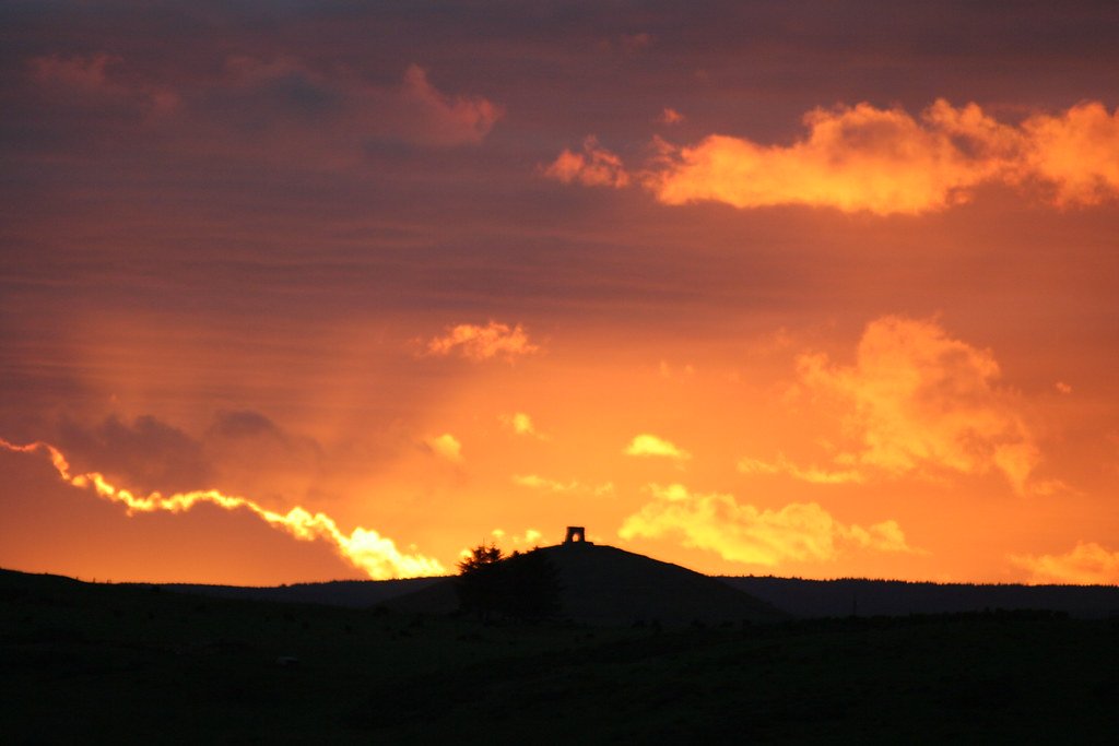
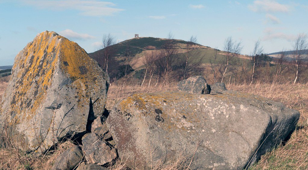
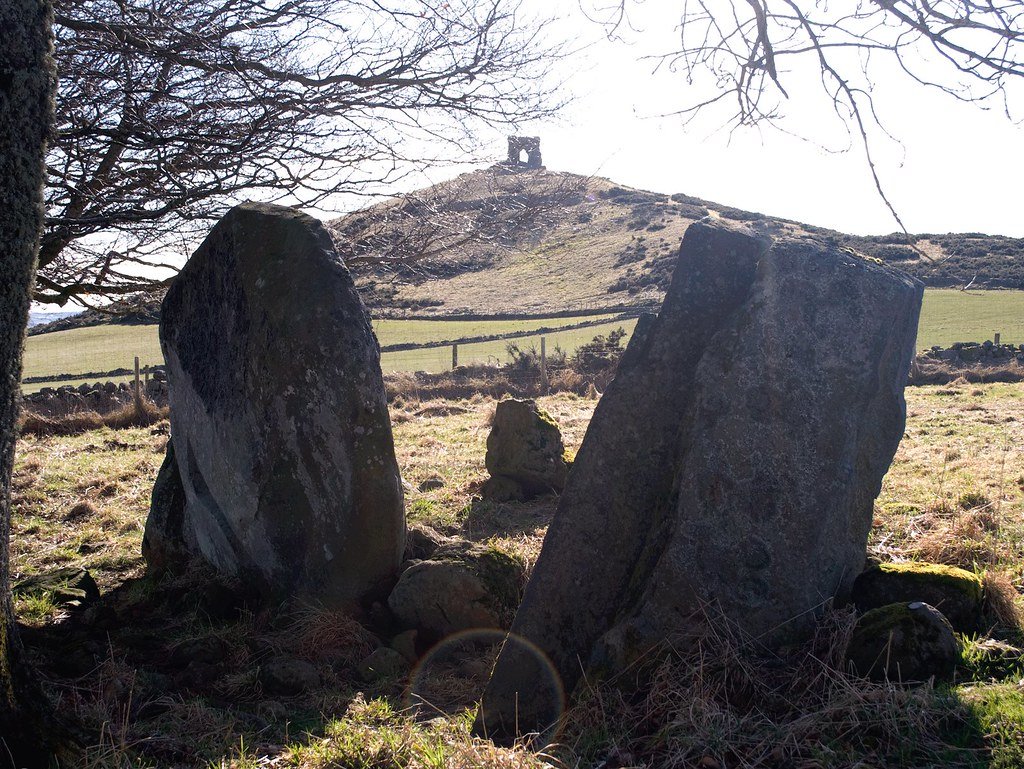
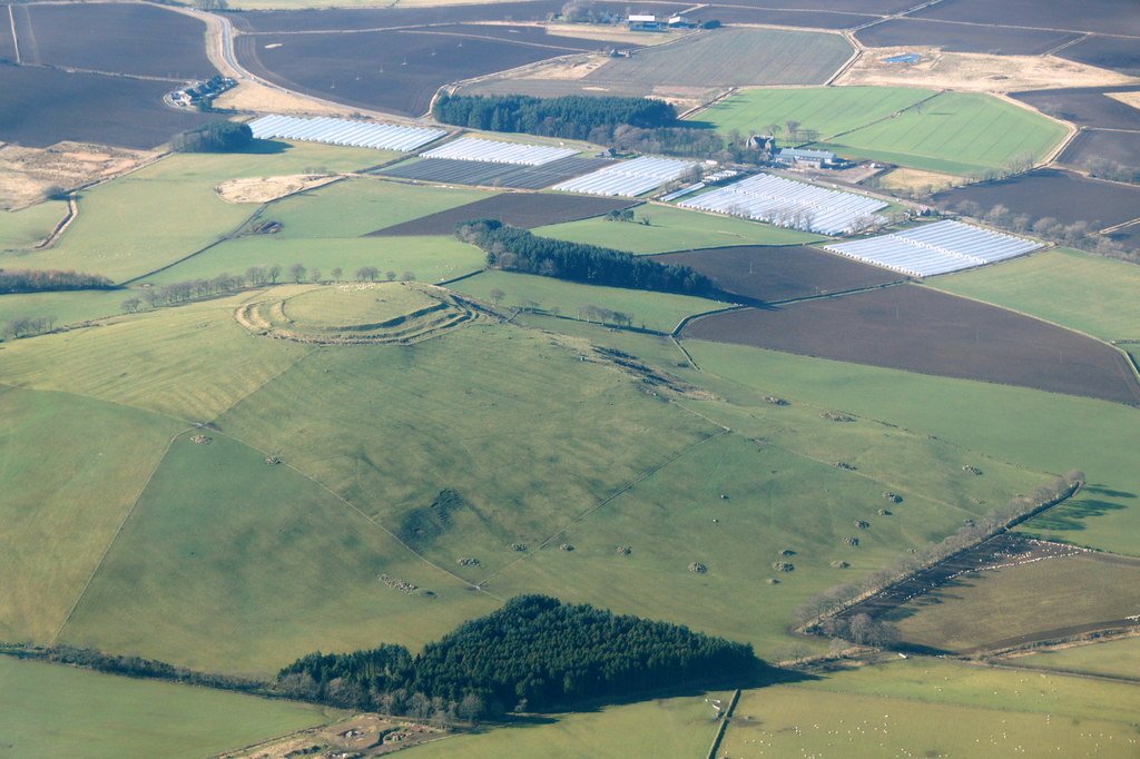
12 miles NW of Inverurie. Access to the group of monuments on Dunnideer Hill is by a signposted footpath from minor road from Insch to Clashindarroch Forrest about 1 mile W of Insch , off the B 992. The Medieval Castle, the most prominent feature in the hill, stands inside, and is built from the debris of, an oblong vitrified fort, a maximum length approximately 70 m, which crowns the summit.
Outworks
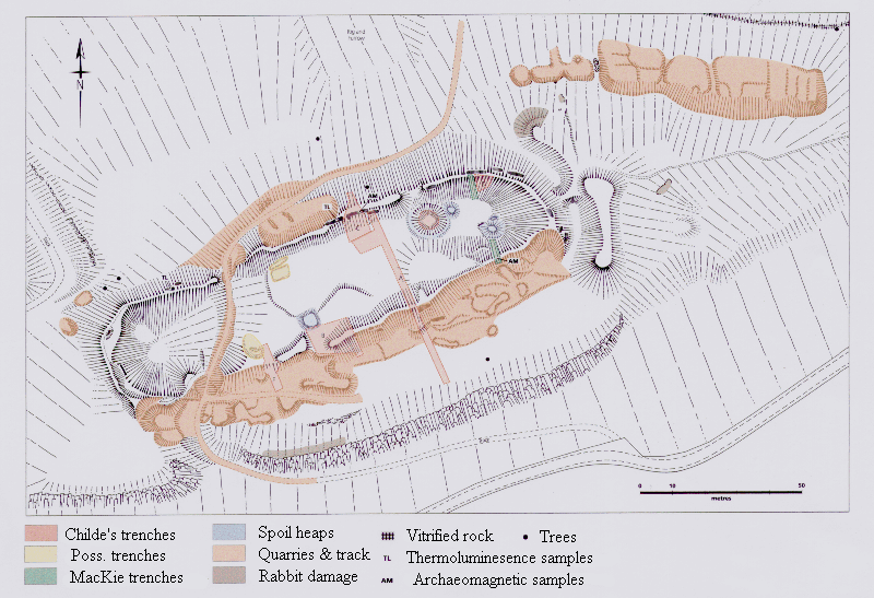
Outworks, most clearly marked on the E, may be associated with this phase. Early features in the interior include a depression adjacent to the castle, which is probably the remains of a cistern or a well. A rectilinear building, set at right angles to the main axis of the vitrified fort, is certainly later in date. Further out and down-slope, traces of slight banks and ditches can be noted: these represent an unfinished defensive scheme, almost certainly later in date than the vitrified fort. On both the N and S slopes, traces of what appear as small grass-covered quarry scoops, fronted by level platforms c 8 m in diameter, can be noted. These represent the stances for timber round-houses, which may date from as early as 1200 BC.
Dunnideer Hillfort – what the evidence tells us so far
Below is a site-centred account that weaves the physical remains together with every episode of investigation, showing how each enquiry refined – and sometimes overturned – earlier ideas.
Setting, form and survival
Attribute
Details
Location
Hill of Dunnideer, 265 m OD, on the western rim of the Garioch, Aberdeenshire (NGR NJ 6128 2756) – a conical knoll overlooking the Bennachie gap and the main Dee–Spey route.
Plan
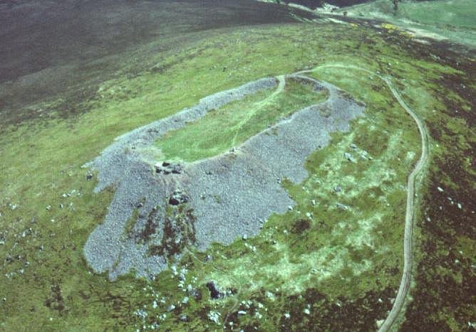
Inner oblong enclosure c. 67 × 27 m, defined by a timber-laced wall 4 – 5 m thick whose core is intensely vitrified on all flanks except the N. Two concentric ramparts and traces of platforms descend the hill, taking the maximum defended area to c. 2.2 ha.
Medieval reuse
A single-cell masonry tower-house (15 × 12.5 m in plan; walls 1.9 m thick) was erected about 1260 CE inside the Iron-Age shell, quarrying large chunks of the slag-fused rampart for building stone. It is regarded as one of the earliest stone tower houses on mainland Scotland.
Timeline of investigation
Date & actor
Work carried out
How it changed our understanding
1770s-1820s – Enlightenment antiquaries
Williams (1777) and Laing (1828) sketched and measured the “Dunnydure” ruins.
First recognition of a man-made wall fused by fire; assumed “Roman-era” origins.
1934 – Scheduling & RCAHMS survey
Fort scheduled; Royal Commission produced a dimensioned plan with five defensive lines.
Confirmed that the oblong vitrified core is only the innermost of several ramparts.
1950s-60s – Feachem & OS field teams
Systematic walkover, tape-and-offset survey, classification as an “oblong, gateless, vitrified fort” within a NE Scottish series.
Placed Dunnideer in a regional group alongside Finavon and Tap o’ Noth, emphasising its timber-laced construction.
1974-76 – Geological/experimental work
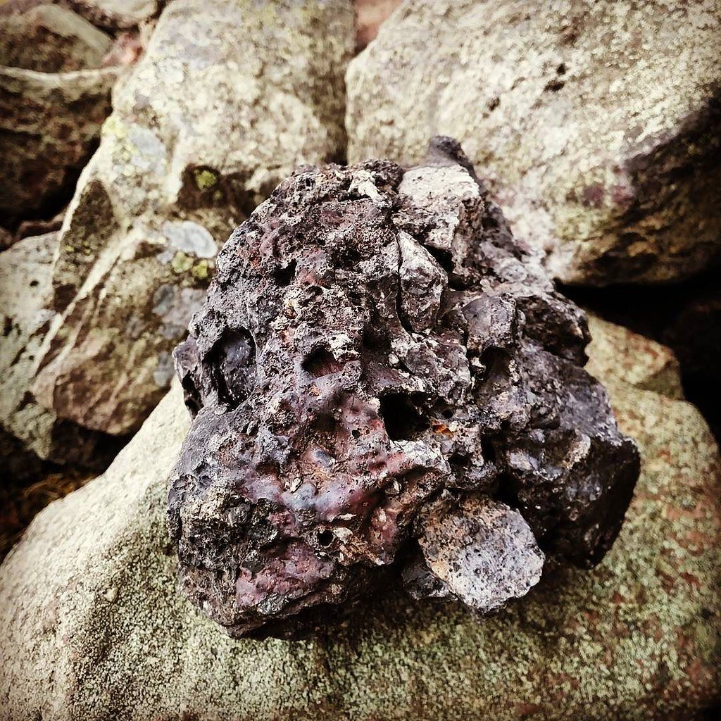
Samples from the rampart used in the first laboratory study of vitrified basalt; OS revision recorded the fire-glazed blocks.
Demonstrated in-situ melting at > 1100 °C and scotched ideas of lightning or volcanic action.
Emergency survey and test-pits after a grass fire scorched the summit.
Located fresh stretches of rampart face and internal scoops hidden by turf.
2007-10 – Hillforts of Strathdon project (M. Cook)
Keyhole trench through the inner wall; bulk slag sampled for radiocarbon and archaeomagnetism: Integration with EDM terrain model.
Two radiocarbon dates on primary charcoal (390-190 cal BC & 370-160 cal BC) and an archaeomagnetic range of 606-257 BC set construction/destruction in the mid-Iron Age (≈ 400-250 BC).
2014-16 – Atlas of Hillforts survey
High-resolution GPS mapping of all ramparts.
Demonstrated that outer lines form a single large enclosure, not disconnected ‘outworks’, and hinted at terrace-houses on the SW flank.
2024-25 – Heritage & outreach
3-D digital model and 1 : 150 exhibition replicas unveiled by Insch Connection Museum.
Popularised the idea that Dunnideer’s tower is built upon – not merely within – an earlier power-centre.
What the datasets now suggest
Chronology – All secure scientific dates cluster in the 3rd–2nd centuries BC for the vitrification event, while architectural comparison makes a late-13th-century date likely for the tower house.
Construction method – Excavation exposed five surviving courses: inner and outer faces of basalt rubble with a timber lacing, whose charring fuelled the vitrification. No doorway was found in the excavated stretch, aligning with the ‘gateless’ morphology of the oblong-fort series.
Scale of firing – Charcoal lenses up to 0.3 m thick on the rampart’s interior suggest deliberate stacking of brushwood against the wall, echoing firing strategies tested experimentally by Childe & Thorneycroft in the 1930s.
Outer defences – Two lower ramparts encircle c. 2 ha; whether they are contemporary with the vitrified wall or later Early Historic refurbishments remains unresolved pending excavation of their banks.
Why Dunnideer matters to research practice
Type-site for “oblong, gateless, vitrified forts” – Together with Tap o’ Noth and Finavon, Dunnideer anchors debate on functions ranging from elite citadels to ceremonial enclosures.
Dating techniques in action – It is one of the few vitrified forts where radiocarbon, archaeomagnetism and micro-petrography have all been applied to the same rampart, making it a calibration point for studies elsewhere.
Medieval adaptation – The 13th-century tower shows how Iron-Age strongholds were recycled as ready-made platforms for high-status residences, a theme echoed at sites like Castle Craig and Edinburgh’s Castle Rock.
Public visibility – Its single standing wall, visible for 30 km across the Garioch, and the short 15-minute hill walk make it an ideal teaching ground for explaining vitrification, multi-period reuse and heritage management in one visit.
Outstanding research questions
Topic
Why it matters
Next steps
Sequence of outer ramparts
Pinpointing whether they are Iron-Age additions or Pictish/Early-Med settlement could reveal long-term continuity.
Was it defensive, symbolic, or a termination rite?
Comparative micro-CT of slag vesicles vs. experimentally fired wall-cores.
Iron-Age economy
No artefact scatter is yet securely associated with the fort interior.
Open-area trench to sample floor deposits & obtain palaeobotanical microfossils.
Tower-house phasing
Establishing whether the tower predates Balliol’s 1260 charter could push back the start of Scottish tower-house architecture.
Mortar-radiocarbon (‘lime-burp’) dating and architectural Photogrammetry.
Dunnideer offers a spectacular, multi-layered case study: a mid-Iron-Age vitrified stronghold whose blazing destruction is fixed to the 3rd–2nd centuries BC, later crowned by one of Scotland’s earliest stone towers. Successive surveys, a wildfire-prompted rescue dig and a single diagnostic trench have taken the site from antiquarian curiosity to a cornerstone in debates about why – and how – Iron-Age peoples set their ramparts ablaze.
A complete silver Scottish twelve shillings coin of James VI of Scotland and I of England, eighth coinage post-dating accession to English throne, dating to 1603-1625, Lys initial mark. Reverse has a shield with arms of [...]
A silver Post-Medieval shilling of Elizabeth I, third issue with ‘A’ initial mark dating to 1583-1585. Mint of London. As North Vol 2, p.136, no.2014. [...]
A lead alloy pipe tamper dating to the 17th century. The plate has moulded decoration to both sides depicting Charles I (facing right) and Henrietta Maria of France (facing left). Both images are contained in [...]
A damaged lead-alloy Medieval pilgrim's ampulla, 50mm in length and 35mm wide, with a round bodied flask with a flaring open top which is partially complete. One side of the flask body has traces of moulded [...]
An incomplete Medieval cast copper alloy buckle plate, dating to c. AD 1100-1400. The plate is missing its buckle and part of its sprues. The buckle plate is sub-rectangular in plan. Projecting from one long edge [...]
A Roman copper-alloy nummus of the House of Valentinian , dating to AD 364-7 (Reece Period 19), GLORIA RO-MANORVM reverse type depicting the emperor with right hand dragging captive right and holding a labarum in left hand. Mint of [...]
A Post-Medieval copper alloy farthing of Charles I (AD 1625-1649), dating to AD 1636-1644. Rose type 2, with sceptres in saltire through single crown. Mint of London. Unclear initial mark. North (1991: 165) no. 2291. [...]
A clipped and heavily worn Roman copper alloy nummus of Gratian (AD 367-383) dating to the period AD 367-378 (Reece period 19). SECURITAS REI PUBLICAE reverse type depicting Victory advancing left, holding a wreath and palm. Unknown mint. [...]
A silver Roman siliqua of Honorius (AD 393-423) dating to the period AD 397-402 (Reece Period 21) minted in Milan VIRTVS ROMANORVM reverse type depicting Roma seated left on cuirass, holding Victory on globe and spear. Hoxne, p. 145, no. [...]
An incomplete Roman composite plate brooch probably dating to AD 100-200. The brooch is missing it's pin and part of the top and bottom circles. The brooch is flat in cross section and probably originally consisted of [...]
Fragment from a probable buckle frame dating to the Post Medieval period (c.AD 1720-1790). The fragment is broadly rectangular in plan and includes a short section of the corner of the buckle frame. The fragment includes the [...]
Fragment from a buckle frame dating to the Post Medieval period (c.AD 1720-1790). The fragment is broadly C shaped in plan and D shaped in profile. It consists of two corners and one side of a sub-rectangular [...]
A complete copper alloy bovine (bull's head) vessel / bucket mount, dating to the Roman period (c. AD 50-200).The cast copper alloy mount is a sub-inverted triangle with a pointed lower tip and slightly waisted sides to form the nose.The [...]
An incomplete copper-alloy early Medieval stirrup strap mount of uncertain or unclassified type, dating to c.AD 1050-1150. The central part of the object survives with parts of the open work broken off on all sides except [...]
A near complete Medieval-Post Medieval cast copper alloy buckle with integrated plate dating to the period c.AD 1250-1500. The buckle is missing its pin.It has a rectangular frame, which has a sub rectangular cross-section. The integral plate has [...]
A very worn copper-alloy Roman radiate or nummus of unclear ruler dating to AD 260-402. Unclear reverse type, unclear mint.The coin is chipped around its circumference. [...]
A very worn Roman copper alloy radiate of uncertain emperor dating to the period AD 260-275 (Reece period 13). Unclear reverse type depicting. Unclear mint. [...]
An incomplete Medieval cast copper-alloy rectangular buckle with integral looped plate, dating to c. AD 1200-1400. The buckle is missing its pin. The buckle comprises a rectangular loop and an integral plate. The plate is made [...]


 Grid ref: NJ 612 281 Ordnance Survey Landranger series sheet no. 37