Castle Point is more than a picturesque headland: it is an amazing display of Iron-Age engineering, Pictish re-fortification, medieval lordship and early-modern coastal defence can all be read in successive layers of stone, timber and vitrified glass. Despite a decade of mid-20th-century digging, key chronological pins and behavioural questions remain open—making the site a prime candidate for 21st-century, minimally invasive science.
Quick orientation
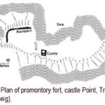
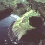
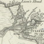
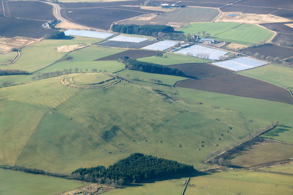
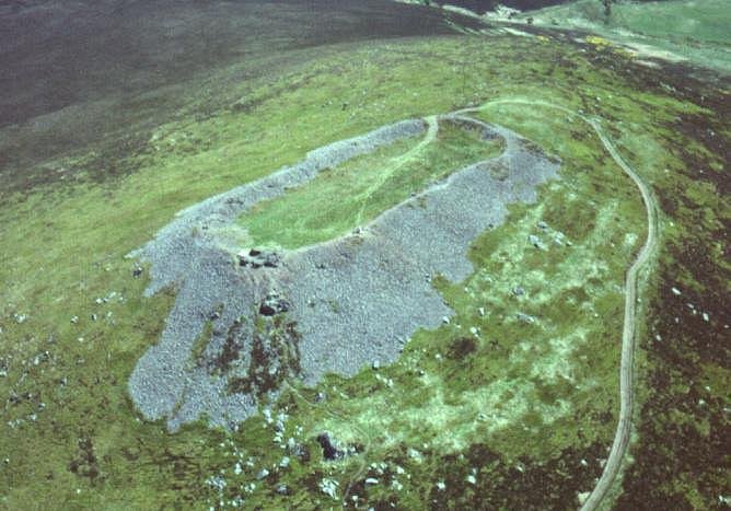
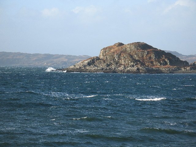
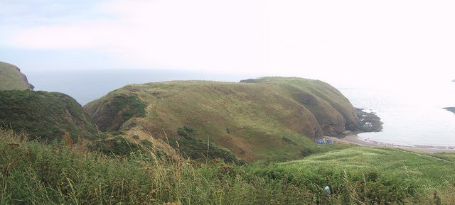
Perched on a sandstone headland just west of Pennan harbour (OS grid NJ 837 661), Castle Point commands a small anchorage and the sea-lane that skirts the Moray Firth. A 4 m-wide isthmus links the point to high ground inland; everywhere else sheer cliffs fall to Cullykhan Bay, giving a naturally defensible promontory of c. 1 ha. (Canmore)
Stratigraphy of occupation
Phase
Date‐range
Main works & features
Notes
Palisaded promontory
late Bronze/early Iron Age (c. 1000–800 BC)
Timber palisade barricading the neck; ring-ditch house & yard surfaces behind.
Vitrified wall-core – Glassy slag bands up to 0.5 m thick prove in-situ firing above 1100 °C, matching the Scottish vitrified-fort tradition. (Canmore)
Radiocarbon & dendro dates – Charred gate-posts and wall-timbers give calibrated ages spanning 750-200 BC, fixing the conflagration firmly in the Middle Iron Age. (online.aberdeenshire.gov.uk)
Craft activity – Furnaces, crucible fragments and mould spatter point to bronze‐ and iron-working inside the fort prior to its destruction. (Britain Express)
Artefact spread – Neolithic flints, jet bracelet pieces, Roman coarse-ware sherds, high-medieval pottery and post-medieval clay-pipes together chart four millennia of intermittent use. (Canmore)
Chronicle of research
Year(s)
Investigators & method
Key outcomes
1777
Rev. Williams sketches “vitrified ruins”
First published notice of prehistoric defences. (Canmore)
1963-72
Aberdeen College of Education Archaeological Society (J C Greig & R H Cairns) – season-long excavations
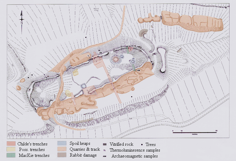
Defined five prehistoric phases, uncovered medieval tower, logged vitrification; left sample trenches open for demonstration. (Canmore)
1971 & 1974 papers
Greig publishes interim & final Iron-Age reports
Sets Castle Point alongside Burghead & Barry Hill in N-east coastal fort sequence. (scarf.scot)
2012
M. Greig’s re-analysis of the castle (PSAS 142)
Detailed building plan, mason’s marks, siege-fire evidence; refined medieval timeline. (Archaeology Data Service)
Quantified erosion, mapped battery earthworks, created 3-D terrain mesh for public outreach. (Historic Environment Scotland)
Why Castle Point matters
Complete coastal sequence – From palisaded promontory through vitrified rampart to gun battery, the site mirrors 2,500 years of changing military technology in one place. (Historic Environment Scotland)
Key vitrification data-set – Rare sandstone-based vitrified wall offers comparative material for temperature modelling otherwise dominated by gneiss and basalt forts. (Canmore)
Gateway Preservation – The timber-laced entrance is one of the best preserved Iron-Age gateways in north-east Scotland, enhancing experimental reconstructions of fort access systems. (online.aberdeenshire.gov.uk)
Community visibility – Short access path from Cullykhan car-park and adjacent beach make the fort ideal for citizen-science geophysics or guided landscape walks. (walkhighlands)
Outstanding questions & research potential
Theme
Why it matters
Next logical step
Function of vitrification
Deliberate show of power, accidental battle damage or ritual closure?
Micro-CT of slag vesicles vs. controlled experimental firing.
Pictish phase dating
Ditches & hall could tighten chronology of coastal lordships.
Targeted OSL & archaeomagnetic sampling in ditch fills.
Medieval tower occupation
Documentary record scant; artefact spread suggests 13th-17th c.
Mortar (lime-burp) radiocarbon & comparison with regional masonry.
Battery service record
Fort Fiddes’ armament and garrison unknown.
Archive search of Admiralty correspondence + metal-detector survey under licence.
Grid ref: NJ 837 661 Ordnance Survey Landranger series sheet no’s 29 and 30
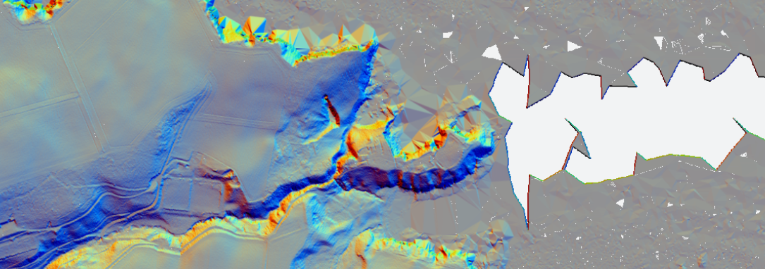
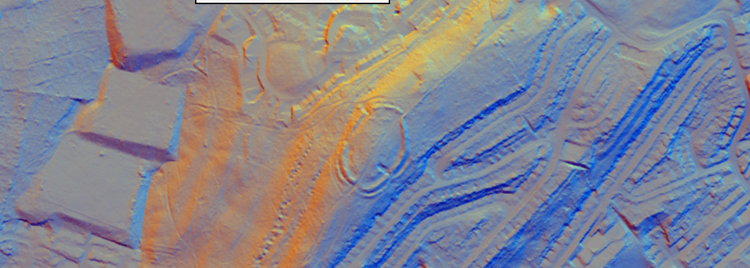
Castle Point Fort - 1m LiDAR - National Library of Scotland
Castle Point Fort - 1752 Roy Map - National Library of Scotland
Notes on Excavations
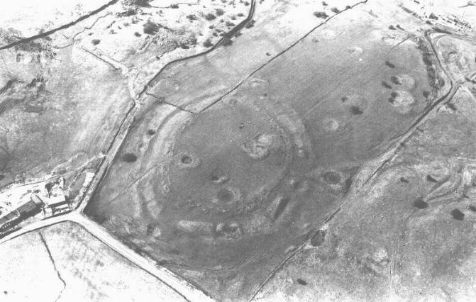
10 miles W of Fraserburgh. Access to this Promontory fort is by a motorable track N from the B9031, W of the steep-sided valley of the Tore of Troup. The site, which dominates the little Cullykhan Bay, is reached by walking along a narrow path NE from the car park. Excavation has illustrated the complex defensive history of this site during later prehistoric times. Initially, the Knoll, marking the landward extremity of the site, was fortified by at least one palisade. This was subsequently replaced by a timber-and-stone wall, related to German examples, with an elaborate gateway. Later still, a smaller area was enclosed by a wall which had been vitrified. Occupation evidence includes indications of metalworkers' workshops. There is also evidence of use, though not fortification, in Dark Age times and the remains of a still later castle. Excavations have revealed remains of a 12th-century structure, including a possible circular timber building on a stone foundation, dated by coins and other artifacts. Additionally, there are earthworks and ditches from the Iron Age, which were part of the fort's defensive system. The site also contains evidence of medieval occupation, with various structural features indicating development into the 13th and 14th centuries. These findings provide a fascinating glimpse into the historical use and evolution of this promontory fort. Excavations have uncovered various fascinating artifacts. Among the finds are coins and pottery, which help date the site's various periods of occupation. Additionally, remnants of a possible circular timber building on a stone foundation were discovered, providing insights into the construction techniques used. Other artifacts include tools and everyday items that shed light on the daily lives of the people who once inhabited this ancient fort.
A complete silver Scottish twelve shillings coin of James VI of Scotland and I of England, eighth coinage post-dating accession to English throne, dating to 1603-1625, Lys initial mark. Reverse has a shield with arms of [...]
A silver Post-Medieval shilling of Elizabeth I, third issue with ‘A’ initial mark dating to 1583-1585. Mint of London. As North Vol 2, p.136, no.2014. [...]
A lead alloy pipe tamper dating to the 17th century. The plate has moulded decoration to both sides depicting Charles I (facing right) and Henrietta Maria of France (facing left). Both images are contained in [...]
A damaged lead-alloy Medieval pilgrim's ampulla, 50mm in length and 35mm wide, with a round bodied flask with a flaring open top which is partially complete. One side of the flask body has traces of moulded [...]
An incomplete Medieval cast copper alloy buckle plate, dating to c. AD 1100-1400. The plate is missing its buckle and part of its sprues. The buckle plate is sub-rectangular in plan. Projecting from one long edge [...]
A Roman copper-alloy nummus of the House of Valentinian , dating to AD 364-7 (Reece Period 19), GLORIA RO-MANORVM reverse type depicting the emperor with right hand dragging captive right and holding a labarum in left hand. Mint of [...]
A Post-Medieval copper alloy farthing of Charles I (AD 1625-1649), dating to AD 1636-1644. Rose type 2, with sceptres in saltire through single crown. Mint of London. Unclear initial mark. North (1991: 165) no. 2291. [...]
A clipped and heavily worn Roman copper alloy nummus of Gratian (AD 367-383) dating to the period AD 367-378 (Reece period 19). SECURITAS REI PUBLICAE reverse type depicting Victory advancing left, holding a wreath and palm. Unknown mint. [...]
A silver Roman siliqua of Honorius (AD 393-423) dating to the period AD 397-402 (Reece Period 21) minted in Milan VIRTVS ROMANORVM reverse type depicting Roma seated left on cuirass, holding Victory on globe and spear. Hoxne, p. 145, no. [...]
An incomplete Roman composite plate brooch probably dating to AD 100-200. The brooch is missing it's pin and part of the top and bottom circles. The brooch is flat in cross section and probably originally consisted of [...]
Fragment from a probable buckle frame dating to the Post Medieval period (c.AD 1720-1790). The fragment is broadly rectangular in plan and includes a short section of the corner of the buckle frame. The fragment includes the [...]
Fragment from a buckle frame dating to the Post Medieval period (c.AD 1720-1790). The fragment is broadly C shaped in plan and D shaped in profile. It consists of two corners and one side of a sub-rectangular [...]
A complete copper alloy bovine (bull's head) vessel / bucket mount, dating to the Roman period (c. AD 50-200).The cast copper alloy mount is a sub-inverted triangle with a pointed lower tip and slightly waisted sides to form the nose.The [...]
An incomplete copper-alloy early Medieval stirrup strap mount of uncertain or unclassified type, dating to c.AD 1050-1150. The central part of the object survives with parts of the open work broken off on all sides except [...]
A near complete Medieval-Post Medieval cast copper alloy buckle with integrated plate dating to the period c.AD 1250-1500. The buckle is missing its pin.It has a rectangular frame, which has a sub rectangular cross-section. The integral plate has [...]
A very worn copper-alloy Roman radiate or nummus of unclear ruler dating to AD 260-402. Unclear reverse type, unclear mint.The coin is chipped around its circumference. [...]
A very worn Roman copper alloy radiate of uncertain emperor dating to the period AD 260-275 (Reece period 13). Unclear reverse type depicting. Unclear mint. [...]
An incomplete Medieval cast copper-alloy rectangular buckle with integral looped plate, dating to c. AD 1200-1400. The buckle is missing its pin. The buckle comprises a rectangular loop and an integral plate. The plate is made [...]


 Grid ref: NJ 837 661 Ordnance Survey Landranger series sheet no’s 29 and 30