Mote of Mark – a Dark-Age citadel above Rough Firth
Setting & basic layout
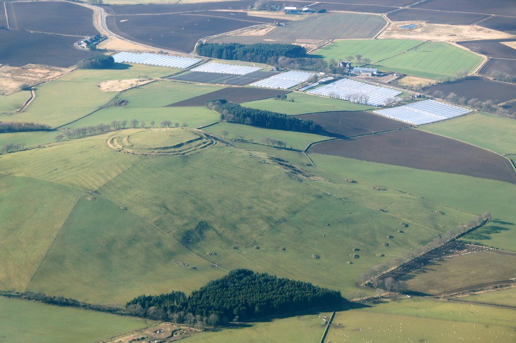
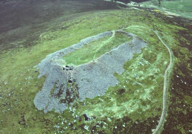
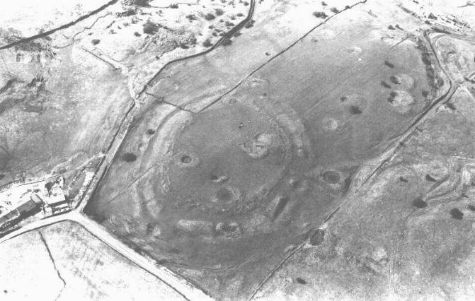
Located on a granite knoll (45 m OD) on the east shore of Rough Firth between Rockcliffe and Kippford, Dumfries-and-Galloway (NGR NX 845 540). The west and south faces drop almost sheer to the estuary; access is by a narrow neck on the north-east. (hillforts.arch.ox.ac.uk, Britain Express)
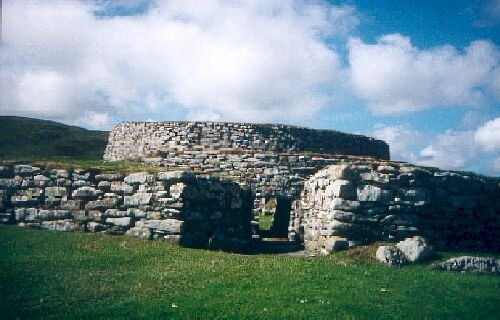
Defences – A single timber-laced stone rampart, c. 4 m thick, once ringed the 0.14 ha summit; most blocks were tumbled downslope after a fierce burning that fused parts of the core into green-black glass. A slighter outer bank and ditch skirt the easier north-east approach. No definite entrance has been located. (Canmore)
Chronicle of investigation
Date
Investigators & method
What they added
1755–1893
Roy’s Military Map, R. Riddell (1790) & J. Coles (1893) sketch-survey
First published notice of a “vitrified fort”; rough plan and section. (hillforts.arch.ox.ac.uk)
1913
Alexander O. Curle cut 13 trenches across rampart and interior
Imported table-wares – 55 sherds of Gaulish E-ware and two Late-Roman (LR 2) amphora fragments place peak occupation in the mid-6th century AD. (books.casematepublishing.com, Canmore)
Glass & gaming pieces – Vessel shards from Frankish glass beakers and a bossed glass gaming counter underscore long-distance connections. (books.casematepublishing.com)
Animal bone & food waste – Dominance of cattle and high proportions of red-deer venison fit a short-lived, high-status residence rather than a farming hamlet. (books.casematepublishing.com)
Dating & historical horizon
Radiocarbon assays on rampart charcoal and occupation layers converge on c. AD 550–700; artefact typology agrees, framing the fort within the post-Roman kingdom of Rheged and the wider Irish-Sea trading zone. (hillforts.arch.ox.ac.uk, books.casematepublishing.com)
Why the Mote matters
Classic vitrified wall south of the Clyde/Forth line – a laboratory for studying firing techniques beyond the better-known Highland forts. (Canmore)
Industrial powerhouse – unparalleled quantity of moulds and crucibles shows that prestigious metal-working was embedded inside a royal seat, not farmed out to satellite workshops. (journals.socantscot.org, books.casematepublishing.com)
Trade cross-roads – Imported wine amphorae, fine pottery and glass prove direct contact with Atlantic Gaul and the Mediterranean during Britain’s so-called “Dark Ages”. (Canmore, books.casematepublishing.com)
Tightly dated destruction – Coherent 6th-century radiocarbon suite plus vitrification raise the prospect that the fort was deliberately torched during early Northumbrian expansion. (hillforts.arch.ox.ac.uk)
Outstanding questions & research potential
Issue
Why it matters
Next step
Who burned the rampart?
Could link the fire to named conflicts in Historia Brittonum.
Pair archaeomagnetic & micro-CT slag studies to refine burn episode.
Extent of craft zoning
Interior still partly unexcavated.
Targeted geophysics and micro-excavations in central hollow.
Outer terrace platforms
Possible worker huts or later reuse?
Coring & OSL dating of terrace fills.
Landscape integration
How did the fort control estuary traffic?
Viewshed & catchment modelling tied to LiDAR.
Vitrified Fort
The Mote of Mark is a defended hilltop overlooking the Urr estuary. It was the court or citadel of a powerful Dark Age chieftain, possibly one of the princes of Rheged. The site was occupied during the 6th century and appears to have been destroyed by fire in the 7th century.
The top of the hill was enclosed by a massive stone and timber rampart. Inside was a timber hall surrounded by a huddle of workshops and stables. This was a wealthy site with trading contacts across Europe. Finds from the excavations include glass beads and wine jars from central France and glassware from Germany. Local craftsmen produced elegant bronze jewellery in a distinctive Celtic style.
The tumbled remains of the ramparts can still be seen, and an on-site interpretation panel has an atmospheric reconstruction of the fort.
Size: 8 ha (20a)
Legendary and Literary Background
https://panther.bsc.edu/~arthur/others.html
This fort was occupied from the 5th to 7th centuries, smack-dab in the Arthurian time frame. At the pinnacle of its prominence, it was a well-fortified trading and manufacturing centre. Excavations in 1913 and 1973 unearthed a large, circular timber hut and evidence of metalworking. These people seemed to have imported raw materials--iron from the Lake District and jet from York--to produce interlaced jewellery, brooches, and sundry metalwork. They imported luxuries as well--pottery from Bordeaux and glass from the Rhineland were found. Such prosperity suggests that this fort may have been the stronghold of a smaller British subkingdom.
Defences
The primary defences consisted of stone and timber walls, and there was a timber gate for the main entrance on the southern slopes. In the 7th century, though, these defences failed. The outer wall shows evidence of vitrification, a condition when extreme heat causes stones to fuse together. Many believe that this was the result of an attack by the Angles--Anglian runic inscriptions were found at the site--though some say that the walls were purposely vitrified to strengthen them.
The only thing truly connecting this fort with the Arthurian legend is the name, its period of occupation, and its proximity to Trusty's Hill.
Dating of Mote of Mark
Radiocarbon determinations on the burnt rampart
Five charcoal samples taken in the 1973 and 1979 campaigns were run at the Scottish Universities Reactor Centre (prefix SRR/ GU). Calibrated with IntCal20, they cluster like this:
Lab code
¹⁴C BP
2σ calibrated span (95 %)
Context
SRR-321
1491 ± 42
AD 430 – 640
Charcoal in vitrified wall core
GU-1313
1570 ± 100
AD 240 – 670
Charcoal lens in secondary wall tumble
GU-1314
1525 ± 100
AD 250 – 800
Charcoal below paving inside gate
GU-1315
1595 ± 100
AD 220 – 660
Charcoal under metal-working floor
GU-1316
1525 ± 100
AD 250 – 800
Charcoal in furnace rake-out
Taken together, the highest‐probability overlap lies in the mid-6ᵗʰ to early-7ᵗʰ century AD.
Imported artefacts that peg the main occupation to c. AD 550–625
Gaulish “E-ware” kitchen pottery – a coarse orange fabric distributed to Atlantic Britain c. AD 550-650. Fifty-five sherds came from Curle’s and Laing & Longley’s trenches. (potsherd.net, Internet Archaeology)
Late-Roman Amphora type 2 (LRA-2) – neck and body fragments whose production and export peak in the later-6ᵗʰ century. (levantineceramics.org)
Frankish glass beaker shards & a bossed gaming piece of Merovingian type, again typical of high-status sites between AD 550 and 620. (Dark Age Digs)
Because these imports all arrived by sea and are unlikely to have lain around for generations, they reinforce the radiocarbon window.
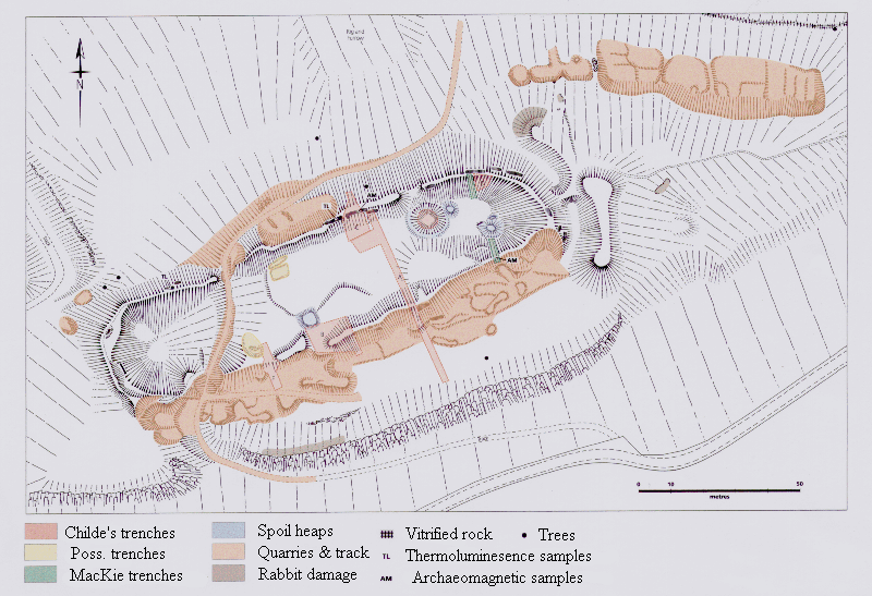
Stratigraphic pointers
Laing & Longley’s stratigraphy shows:
Construction of the timber-laced rampart.
A short phase of intensive non-ferrous metal-working (hundreds of clay mould fragments and crucibles).
Catastrophic burning and vitrification that collapsed the wall and sealed the workshop floors.
The charcoal dated above comes from that conflagration horizon, so the scientific dates time-stamp the fort’s destruction, not just its use.
Putting the pieces together
Evidential strand
Convergent date-band
¹⁴C on rampart & industrial floors
AD 430–640 (modal peak c. 550–600)
E-ware imports
AD 550–650
Frankish glass & LR 2 amphora
AD 550–620
Atlas of Hillforts synthesis
Start c. AD 550, end c. AD 700
Consensus view: the Mote of Mark was founded in the mid-6ᵗʰ century (around AD 550), flourished for perhaps two or three generations as a royal/workshop centre within the kingdom of Rheged, and was destroyed by fire—very likely in the early-7ᵗʰ century (c. AD 600–630).
What is still uncertain?
Whether there was a short reoccupation after the burn (uppermost layers were badly eroded before excavation).
Which enemy—or internal faction—set the fort ablaze; historical candidates range from Bernician Northumbria to dynastic rivals within Rheged.
Precise length of the metal-working episode (industrial debris is dense but stratigraphically compressed).
Bottom line: the Mote of Mark is not undated. Multiple radiocarbon assays, tightly datable continental imports and coherent stratigraphy all point to a main life-span of roughly AD 550 to 630, with the vitrified rampart sealing the very end of that story.
A complete silver Scottish twelve shillings coin of James VI of Scotland and I of England, eighth coinage post-dating accession to English throne, dating to 1603-1625, Lys initial mark. Reverse has a shield with arms of [...]
A silver Post-Medieval shilling of Elizabeth I, third issue with ‘A’ initial mark dating to 1583-1585. Mint of London. As North Vol 2, p.136, no.2014. [...]
A lead alloy pipe tamper dating to the 17th century. The plate has moulded decoration to both sides depicting Charles I (facing right) and Henrietta Maria of France (facing left). Both images are contained in [...]
A damaged lead-alloy Medieval pilgrim's ampulla, 50mm in length and 35mm wide, with a round bodied flask with a flaring open top which is partially complete. One side of the flask body has traces of moulded [...]
An incomplete Medieval cast copper alloy buckle plate, dating to c. AD 1100-1400. The plate is missing its buckle and part of its sprues. The buckle plate is sub-rectangular in plan. Projecting from one long edge [...]
A Roman copper-alloy nummus of the House of Valentinian , dating to AD 364-7 (Reece Period 19), GLORIA RO-MANORVM reverse type depicting the emperor with right hand dragging captive right and holding a labarum in left hand. Mint of [...]
A Post-Medieval copper alloy farthing of Charles I (AD 1625-1649), dating to AD 1636-1644. Rose type 2, with sceptres in saltire through single crown. Mint of London. Unclear initial mark. North (1991: 165) no. 2291. [...]
A clipped and heavily worn Roman copper alloy nummus of Gratian (AD 367-383) dating to the period AD 367-378 (Reece period 19). SECURITAS REI PUBLICAE reverse type depicting Victory advancing left, holding a wreath and palm. Unknown mint. [...]
A silver Roman siliqua of Honorius (AD 393-423) dating to the period AD 397-402 (Reece Period 21) minted in Milan VIRTVS ROMANORVM reverse type depicting Roma seated left on cuirass, holding Victory on globe and spear. Hoxne, p. 145, no. [...]
An incomplete Roman composite plate brooch probably dating to AD 100-200. The brooch is missing it's pin and part of the top and bottom circles. The brooch is flat in cross section and probably originally consisted of [...]
Fragment from a probable buckle frame dating to the Post Medieval period (c.AD 1720-1790). The fragment is broadly rectangular in plan and includes a short section of the corner of the buckle frame. The fragment includes the [...]
Fragment from a buckle frame dating to the Post Medieval period (c.AD 1720-1790). The fragment is broadly C shaped in plan and D shaped in profile. It consists of two corners and one side of a sub-rectangular [...]
A complete copper alloy bovine (bull's head) vessel / bucket mount, dating to the Roman period (c. AD 50-200).The cast copper alloy mount is a sub-inverted triangle with a pointed lower tip and slightly waisted sides to form the nose.The [...]
An incomplete copper-alloy early Medieval stirrup strap mount of uncertain or unclassified type, dating to c.AD 1050-1150. The central part of the object survives with parts of the open work broken off on all sides except [...]
A near complete Medieval-Post Medieval cast copper alloy buckle with integrated plate dating to the period c.AD 1250-1500. The buckle is missing its pin.It has a rectangular frame, which has a sub rectangular cross-section. The integral plate has [...]
A very worn copper-alloy Roman radiate or nummus of unclear ruler dating to AD 260-402. Unclear reverse type, unclear mint.The coin is chipped around its circumference. [...]
A very worn Roman copper alloy radiate of uncertain emperor dating to the period AD 260-275 (Reece period 13). Unclear reverse type depicting. Unclear mint. [...]
An incomplete Medieval cast copper-alloy rectangular buckle with integral looped plate, dating to c. AD 1200-1400. The buckle is missing its pin. The buckle comprises a rectangular loop and an integral plate. The plate is made [...]


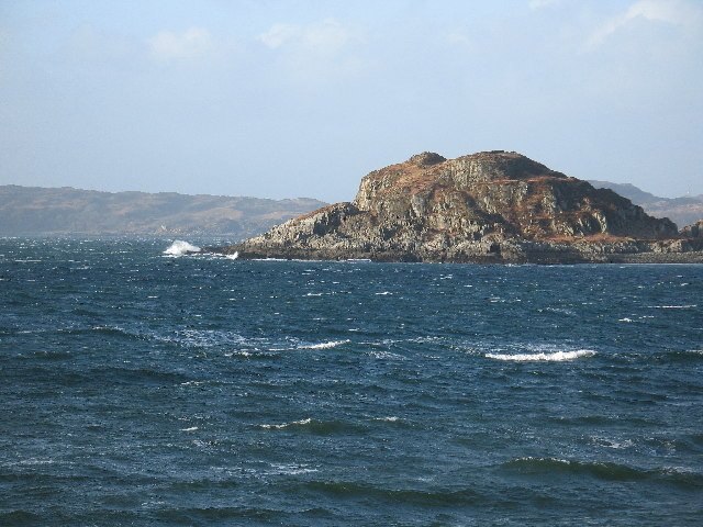

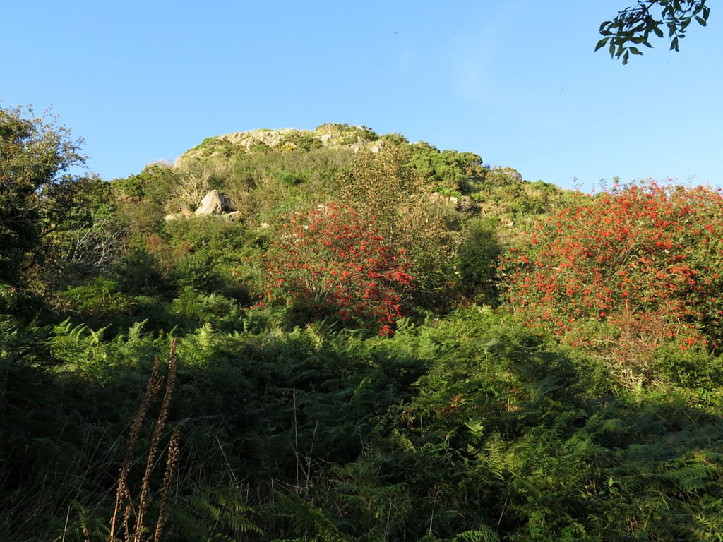 "Mote of Mark from sea shore path - geograph.org.uk - 6273954" by Andrew Curtis is licensed under CC BY-SA 2.0
 Classic vitrified wall south of the Clyde/Forth line – a laboratory for studying firing techniques beyond the better-known Highland forts. (Canmore)


