Galicia’s Celtic origins have long played a significant role in shaping the region’s cultural and political identity. Historically, Galicia was Read more
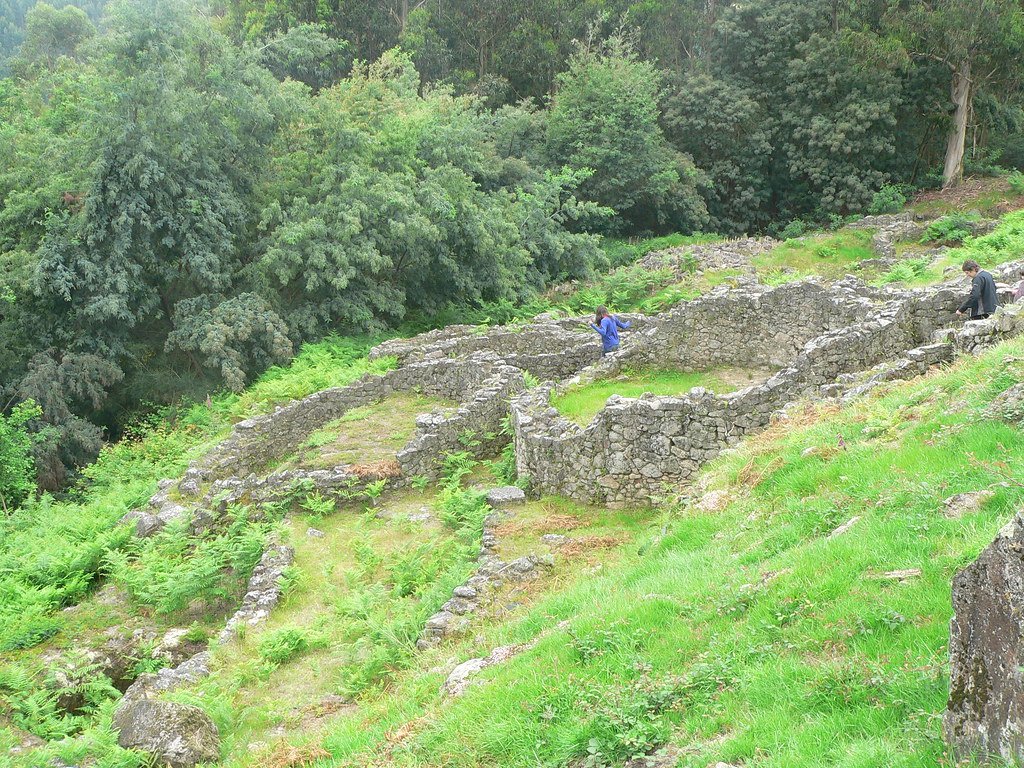
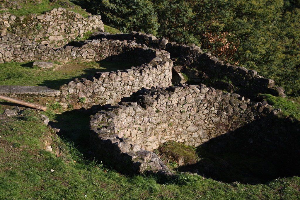
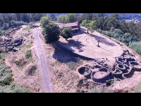
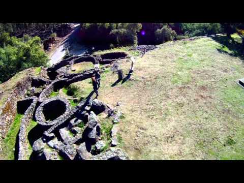
Castro de Trona is an oval enclosure with significant terracing to the west and a large ditch to the east. This castro (a hillfort settlement) has an accepted date of around 600 BCE. Like many others in Galicia, this castro reached its peak during the 1st and 2nd centuries CE. It measures approximately 200 metres east to west by 150 metres north to south.
Attribute
Summary
Type / Culture
Galician hill‑fort (castro) belonging to the late “Castro Culture” (Late Iron‑Age → Early Roman contact).
Location
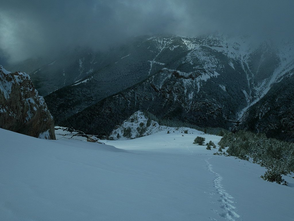
Parish of Pías, municipality of Ponteareas, 225 m a.s.l. on Monte do Dulce Nombre de Jesús, overlooking the Louro–Tea–Miño river corridor (strategic control of two natural routes into inland Galicia). (Turismo de Galicia)
Chronology
First occupation ≈ 5th century BC (earliest stone structures); peak density c. 2nd–1st century BC; Romanised refurbishments 1st–2nd century AD; sporadic use into late antiquity. (turismoriasbaixas.com, ponte-verde.destino.gal)
Legal status
Declared Bien de Interés Cultural (BIC) 1931; managed today by Concello de Ponteareas & Xunta de Galicia heritage service.
Discovery, research & excavation
1890s–1910 – First antiquarian digs; wall‑tracing plans published.
1981‑1992 – Systematic campaigns led by the Pontevedra Provincial Museum (A. Méndez & M. C. Pereira), opening >3 ha, clarifying fortifications, house plans and Roman levels. (ponte-verde.destino.gal)
Oval enceinte c. 200 m (E‑W) × 150 m (N‑S) (≈ 2.6 ha).
Eastern approach protected by a 7 m‑wide rock‑cut ditch, counterscarp bank and inner cyclopean stone rampart.
Western terraces artificially widened into three habitational “streets”; revetment walls double as retaining structures.
Upper platform holds a circular sacred enclosure (interpreted as a coroa or communal sanctuary).
Domestic & public architecture
More than 50 structures have been mapped:
Round or oval houses (4–6 m Ø) of schist masonry, thatched conical roofs; internal stone benches and hearth slabs.
Rectangular workshops (smithy/loom) date to the Roman horizon (tiles, tegulae).
Paved lanes flagged with local granite, channelling rainwater downslope.
‘Pedra da Serpe’, an inscribed serpent‑relief orthostat reused in a house wall, probably a pre‑Roman cult stone later Christianised. (turismoriasbaixas.com)
Material culture & economy
Class
Highlights
Significance
Ceramics
Burnished coarse ware; fine grey ware; imports of Hispanic terra sigillata (mid‑1st c. AD).
Show gradual incorporation into Roman trade circuits.
Metals
Tinned bronze fibulae, torcs; iron blade tools; slag pits on the west terrace.
Indicates on‑site smithing; social display jewellery.
Mixed agro‑pastoral economy with woodland gathering.
Coins & small finds
Republican denarii, Augustan asses.
Confirm activity during early Roman conquest of Gallaecia (c. 25 BC onward).
Castro de Trona fort - Satellite - Google Maps
Inter‑site networks
Troña’s siting above the Tea–Miño valley puts it in a micro‑cluster with castros of Monte Aloia, Altamira and Coto da Eira. Shared pottery fabrics suggest inter‑marrying communities and exchange; Troña likely functioned as a gateway between inland mining districts and coastal salt/fish producers.
Decline & afterlife
Occupation waned in the late 2nd century AD, echoed by abandonment layers and roof‑tile collapse. Hypotheses:
Administrative re‑organisation under Roman civitas Bracarensis drew population to new vicus in the Louro valley.
Exhaustion of arable terraces; shift to villa agriculture downstream.
Medieval pottery is virtually absent, but local lore preserved the site as “Cidade da Moura”; the serpent stone became a Christian cross‑shrine, explaining its survival.
Visiting today
A marked trail from Pías hamlet climbs to the north gate; low walls are consolidated, and interpretative panels (Gal/Eng/Es) illustrate Iron‑Age house reconstructions. Artefacts are displayed in the Museo Provincial de Pontevedra (Rooms 5 & 6).
Best-preserved inland castro in southern Galicia
Its clear ramparts, well‑spaced terraces and Roman reuse layers make Troña an excellent laboratory for understanding the transition from autonomous hill‑fort societies to Roman municipal structures; Engineering solutions (terrace revetments) in hilly Atlantic settings as well as religion‑symbolic continuity, exemplified by the serpent stone and the later hermitage built atop the castro.
Troña complements coastal classics like Barona, offering a fuller picture of Galician Iron‑Age resilience and adaptation.
Unwanted cookie prevention
Clicking on this image will load the YouTube video, and you will get exactly the same cookies as if you were on the YouTube website directly
For more information, see our cookie policy at: YouTube Cookies
Unwanted cookie prevention
Clicking on this image will load the YouTube video, and you will get exactly the same cookies as if you were on the YouTube website directly
For more information, see our cookie policy at: YouTube Cookies
Information on the Terraces
The terraces connected to the castro have been surveyed, however, mapping is scattered across excavation reports, museum archives and, more recently, digital‐heritage surveys. Below is what exists and how reliable each dataset is.
Year / Project
Technique & scale
Where to find it
What it shows
1981–1992 “Museo de Pontevedra” campaigns (A. Méndez, M. C. Pereira)
Hand‑drawn 1 : 200 stone‑by‑stone plan; 12 sectional profiles across the west‑slope terraces
Provincial Museum archive, Memoria de Excavaciones vols. 1984‑1994 (unpublished PDF scans on request)
First full count of three habitation terraces west of the enceinte, noting wall thickness, stair cuts and drainage slots.
2003 topographic survey (Xunta de Galicia, Servicio de Patrimonio)
Total‑station grid tied to IGN benchmarks; 0.5 m contour map (AutoCAD DWG)
Xunta heritage GIS (internal), summary in Anuario Arqueolóxico de Galicia 2005
High‑resolution 3‑D model – lets you see terrace revetment faces, stepped house pads, rock‑cut drains.
2021 “Castros no Miño‑Louro” research grant
Ground‑penetrating radar transects on terrace fill
Preliminary results in Gallaecia 40 (2023)
Confirms anthropic fill layers (roof‑thatch → midden → clay) and post‑holes for internal staircases.
What does the mapping tell us?
Count & layout of the terraces– three major steps on the western/south‑western slope, each 4–7 m wide, running parallel to the enceinte.
Elevation drop – ~9 m from acropolis to lower terrace; rock‑cut berms behind every revetment keep the rampart stable.
Revetment build – outer face of large schist blocks (up to 1 m), inner packing of smaller stones and clay; drainage slits every 3–4 m.
House pads – round huts (4–5 m Ø) on lower step; elongated workshop buildings (up to 9 m) on mid‑terrace; elite compounds (multi‑room) on upper step.
Fort–Terrace Dynamics at Castro de Troña
Aspect
Evidence
Interpretation
Construction sequence
Excavations (1981–92) show the primary rampart was cut into bedrock first; terrace revetments ≈ 0.5–1 m thinner and sit against the inner face of that rampart.
Terracing is a secondary adaptation: once the defensive shell was in place, households created habitable platforms on the steep western and southern slopes.
Engineering logic
Revetment walls are built in the same cyclopean schist as the enceinte, but with lighter packing and frequent vertical drain‑slits; terrace fill is a layer cake of clay, midden, roof‑thatch, then beaten earth floor.
The terraces function as buttresses—they prop the rampart externally while reclaiming level space inside. This dual purpose maximises living area without widening the crest (which would require more masonry).
Rainwater management
Flagstone lanes slope gently inboard; cut‑stone channels drop water into voids behind terrace walls, outletting through masonry spouts.
The fort–terrace system is hydrologically integrated: preventing water pressure build‑up preserves both habitation floors and the defensive wall.
Terracing expresses a vertical social gradient: elite or ritual space at the summit, specialised craft middens mid‑slope, and ordinary dwellings lower down—yet all remain within the fort’s line of walls.
Agricultural interface
Colluvial sediments at the base of terraces contain cereal pollen and quern fragments, but shallow soils on the actual steps rarely show cultivation traces.
Terraces were domestic/craft zones, not garden plots. Fields likely lay beyond the ditch; the terraces instead densified occupation inside the fort for security.
Roman refurbishments
1st–2nd‑century AD tile scatters concentrate on upper terrace revetments; two buttresses were rebuilt in opus caementicium (cement) and tile copies.
Roman contact triggered structural reinforcement, not abandonment—suggesting the terrace package remained vital as the fort evolved into a semi‑Romanised Oppidum.
Summary
Castro de Troña’s terraces are not after‑thoughts tacked onto a hill‑fort; they are the architectural hinge that lets steep topography, population pressure and defence work together:
Structural synergy – each terrace braces the main enceinte while unlocking habitable acreage.
Social coding – elevation doubles as a social map, concentrating ritual power and elite dwellings nearest the acropolis.
Adaptive longevity – Roman‑period repairs show the terrace–rampart complex was resilient enough to merit investment, underpinning Troña’s role as a local hub well into the imperial era.
These terraces serve to transform what could have been a single cramped summit fort into a multi‑level, multifunctional hill town, showing that this hillfort was probably expanded by way of creating more land via terracing. This will have enabled for increased habitable space, but also, agricultural and animal husbandry space.
Terracing at Castro de Troña in comparative perspective
(contrasted with three neighbouring hill‑forts on the Louro–Tea–Miño corridor)
Attribute
Troña (Ponteareas)
Monte Aloia (Tui)
Coto da Eira (Salceda)
Altamira (As Neves)
Take‑away pattern
Topography & base geology
Steep W–SW slope on schist spur (225 m a.s.l.)
Granite peak ridge, gentler apron
Low schist knoll above Louro floodplain
Quartz‑rich spur, abrupt N face
Geology dictates how many terraces can be cut and how well walls survive.
No. of major habitation terraces
3 stepped shelves W & SW of the inner enclosure.
1 broad ledge on SE quadrant
2 narrow ledges west & north
2 ledges on N‑NW; faint 3rd eroded
Troña shows the most intensive internal terracing in the local cluster.
Revetment build
Cyclopean schist blocks (up to 1 m) + clay packing; drain slits every 3‑4 m
Coarser granite boulders; no built drains – water sheds over ledge edge
Only Troña exhibits a designed water‑management network.
Roman refurbishment evidence
Opus caementicium (Roman cement) buttress + tile scatters on top terrace
Scattered tegulae but no masonry repairs
Nil – abandoned before Roman conquest
Tile dumps on north‑ledge; minor wall patching
Troña & Altamira were maintained under Rome; others contract/abandon.
Key similarities
Terracing as space‑creation – All four sites carve at least one artificial shelf on steeper flanks to fit extra dwellings without enlarging the rampart circuit.
Round‐house norm – Primary domestic units remain circular/oval despite terrace geometry; rectangular buildings appear only where Roman imports (Troña, Altamira).
Sequence: wall → terrace – Stratigraphy shows the defensive enceinte is cut first, terracing afterwards, implying defence dictated site layout.
Distinctive features of Troña
Triple terrace suite – No other Louro–Tea fort packs three clear, architecturally bonded steps; this points to higher population density or a more ambitious community plan.
Engineered drainage – Troña’s revetments include weep‑slits and stone culverts tied to paved lanes – a complexity absent at Monte Aloia or Coto da Eira.
Functional zoning – Vertical separation (elite, craft, common) indicates a degree of social differentiation not as pronounced in neighbouring forts.
Roman‑era investment – Concrete buttressing and tile‑roof refurbishments suggest Troña retained status as a local centre into the 2nd c. AD, whereas Coto da Eira appears deserted by then.
Interpretive implications
Defence vs. demography – More terraces ≈ need to house a larger community while staying behind a single wall; hence Troña’s three tiers mark it as the largest inland castro in the corridor.
Hydraulic planning – Integrating drains implies conscious engineering knowledge—perhaps exchanged via contacts with coastal Oppida or early Roman surveyors.
Social signalling – Elevated elite compounds overlooking lower craft huts signal rank without formal palatial architecture; Troña’s terraces thus serve both practical and ideological roles.
In sum, Castro de Troña’s terracing system is the most carefully engineered and socially stratified among its immediate neighbours, illustrating how individual communities tweaked a shared Atlantic hill‑fort template to meet local topography, population needs and, later, Roman influences.
Local mythology linked to Castro de Troña
Motif
Story elements (common versions)
What it reveals
A serpe‑moura “guardian”
A beautiful moura encantada (enchanted maiden) – sometimes half‑woman, half‑serpent – is said to appear at midsummer dawn, combing her hair with a golden comb beside the Pedra da Serpe. She offers treasure to anyone who can answer her riddle or break her spell with a single kiss; failure turns the intruder to stone.
Typical of Galician hill‑fort lore: the moura personifies pre‑Christian powers and “guards” ancient wealth. Troña’s carved serpent stone fits the widespread belief that these maidens are shape‑shifting guardians of serpentine cult sites.
The buried golden serpent
Peasant versions claim a hollow gallery under the upper terrace hides a coiled gold serpent. Anyone digging without the moura’s permission will unleash misfortune or storms.
Aetiological tale warning locals against treasure hunting; echoes the archaeological reality that the castro still conceals sub‑soil structures.
Christianisation by a hermit‑saint
A hermit (locally identified as San Xulián or San Xurxo) erected a wooden cross over the serpent stone, “taming” the pagan spirit. Later, villagers processed to the castro each 29 September (San Miguel) to bless crops and livestock.
Typical narrative of superimposing Christian ritual on an earlier cult focus; explains the survival of the serpent relief now surmounted by a cross.
Night‑fall lights (“luzes de moura”)
Blue‑white flames are said to flicker over the rampart on certain feast‑eves – souls of the ancient Troñeses or signals of hidden treasure.
Part of broader Galician lumiñas folklore (will‑o’‑the‑wisp), often reported above prehistoric sites and thought to mark burials or treasure pits.
Sources & parallels
Local oral accounts recorded by Xosé L. Méndez (Museo de Pontevedra field notebooks, 1984); consolidated in Lendas do Miño Medio (2010).
Folklore typology in X.‑L. Mariño & A. Lorenzo, Mouras, Mouros e Serpes na Tradición Galega (Compostela, 2016).
Comparative study in C. Parcero‑Oubiña, “Symbolic Stones and Christian Crosses: Continuity at Galician Castros,” Journal of Atlantic Archaeology 9 (2023) 67‑91.
These legends follow a pattern seen at many north‑western Iberian hill‑forts: a pre‑Roman serpent or chthonic cult re‑interpreted as an “enchanted Moorish maiden,” later capped by Christian symbols to neutralise the old power while keeping the site’s sacred aura alive in popular memory.
Snake related archaeological finds in the region
As already mentioned, there is a strong connection between Castro de Trona, so I thought I would see what other snake related finds the general region, Below is a chronological digest of the main snake‑related archaeological finds and images documented so far in Galicia and the adjoining Miño valley, starting with the oldest secure evidence. Where a date range is uncertain I give the best scholarly estimate and note the debate.
Period (cal BC/AD)
Find / site
Object / motif
Notes & significance
c. 1500–900 BC (Late Atlantic Bronze Age)
Petroglyph clusters at Campo Lameiro, Cotobade & Mogor (Pontevedra)
Repeated sinusoidal grooves interpreted by several researchers as stylised serpents or rivers; often paired with cup‑marks or concentric circles.
Among the oldest “snake‑like” carvings on the Atlantic façade; part of a wider Bronze‑Age iconography that links water‑courses, fertility and serpents. (rockartscandinavia.com)
c. 900–400 BC
Pedras da Serpe outcrops (Corme‑Laxe coast; Penalba near Campo Lameiro; Troña itself)
High‑relief serpent‑body with raised head, later capped by a granite cross.
Rock‑cut reliefs usually attributed to Late Iron‑Age castro people and reused in the Christian period; Troña’s own “serpent stone” is the best inland example. (caminosdomar.com, turismo.gal)
5th–2nd c. BC
Gold serpent‑head torcs & bracelets from castros of Santa Tegra (A Guarda), Castro Alobre (Vilagarcía) and chance find at Betanzos (2023)
Terminal ends modelled as coiled or open‑mouthed snakes; sometimes in pairs biting the hoop.
Status jewellery of the Castro Culture elite; snake imagery may denote protection, lineage, or fertility. (World History Encyclopedia, Reddit)
2nd–1st c. BC
Castro de Troña – “Pedra da Serpe” orthostat (now under a cross)
Limestone slab with carved serpent in relief; reused in a hut wall.
Likely a cult marker before Christianisation; core of local moura‑serpe folklore. (World History Encyclopedia)
1st c. AD (early Roman)
Bronze figurine of a serpent‑twined altar, Castro de Borneiro (A Cabana)
Portable household shrine depicting twin snakes approaching an offering dish.
Shows rapid adoption of the Roman lares‑penates icon with serpents as domestic guardians. (Illustrated in ARA Bulletin 14, p. 8) (associationromanarchaeology.org)
1st–3rd c. AD
Altars and mosaics from Lucus Augusti (Lugo) and Bracara Augusta (Braga)
Stone votive altars to health deities with pair of crawling serpents below the inscription; floor mosaics with knot‑snakes.
Demonstrates continuity: the serpent remains a protective, prosperous symbol under Rome. (Alamy)
What the distribution tells us
Continuity, not rupture – From Bronze‑Age rock art through Iron‑Age jewellery to Roman household shrines, the serpent motif never truly disappears; it seems to have been re‑contextualised as its thematic importance was carried over into the changing society. (prehistoric fertility → castro guardian spirit → Roman prosperity‑snake).
Hill‑fort focus – Almost every Iron‑Age serpent image (relief stones, gold torcs) comes from a castro or its immediate environs, reinforcing the idea that hill‑fort communities had a distinct ophidian cult or badge.
Coastal ↔ inland dialogue – Coastal sites (Corme, Santa Tegra) and inland strongholds (Troña, Borneiro) share the same iconography, hinting at a connected belief‑network across the Miño estuary and Rías Baixas.
Mythological after‑life – Medieval and modern moura‑serpe legends cling to the very stones (e.g., Troña, Pedra da Serpe) where the prehistoric carvings survive, suggesting strong cultural memory of the snake as a watchful, wealth‑guarding spirit.
A Probable Neolithic flint piece of debitage possbily intended to be a blade.The fragment is made from a tertiary flake of semi-glossy light grey flint with slightly darker grey patches. It is sub-triangular in plan [...]
A very worn and chipped Roman copper alloy radiate of uncertain emperor dating to the period AD 260-275 (Reece period 13). Unclear reverse type depicting figure standing left. Unclear mint. [...]
A heavily worn Medieval silver 'short cross' cut farthing of an uncertain monarch, Henry II to Henry III dating to the period c.1180-1247. Not further defined.Length: 9.6mm; width: 9.4mm; thickness: 0.5mm; weight: 0.4g. [...]
Silver medieval penny of an uncertain ruler, probably Henry V to Henry VI (1413 - 1461) minted at York. The coin is in poor condition, is 16mm in diameter and weighs 1.00g. [...]
A Roman copper-alloy radiate of Tetricus I/II dating to circa AD 271-274 (Reece Period 13). PAX AVG reverse type depicting Pax standing left holding branch and vertical sceptre. Gallic Mint I. [...]
A Roman copper-alloy nummus of Magnentius or Decentius dating to AD 250-253 (Reece Period 18). VICTORIAE DD NN AVG ET CAE reverse type depicting two Victories holding wreath inscribed [VOT/V/MVLT/X]. Mint of Trier. [...]
A Roman silver denarius of Antoninus Pius (AD 138-161) dating to AD 154-155 (Reece Period 7). COS [IIII] reverse type depicting Fortuna, draped, standing right, holding rudder, vertical on globe, in right hand and cornucopiae, with tip [...]
A Roman copper-alloy barbarous radiate copying a coin of Victorinus (AD 268-270) dating to circa AD 275-285 (Reece Period 14). Copying PAX AVG reverse type depicting Pax standing left holding branch and transverse sceptre. Unclear [...]
A Roman copper-alloy radiate of Carausius (AD 286-293) dating to circa AD 286-293 (Reece Period 14). PAX AVG reverse type depicting Pax standing holding branch and vertical sceptre. Unclear mint. [...]
A Roman copper alloy radiate of Tetricus II (AD 272-274) dating to circa AD 272-274 (Reece Period 1). [SPES AVG] reverse type depicting Spes walking left holding branch and raising hem of robe. Unclear mint. [...]
A free-standing pierced stone weight of uncertain age, but probably dating to the Post Medieval period.The object is sub-square in plan and rectangular in cross section. Its sides appear to have been sanded to give [...]
A Roman copper-alloy barbarous radiate copying a coin of Divus Claudius II (AD 270-271) dating to circa AD 275-285 (Reece Period 14). Copying CONSECRATIO reverse type depicting altar with crescent. Unclear prototype mint. [...]
A free-standing cast lead conical 12.43g weight of uncertain age, but probably dating to the Post Medieval period.It has a sub-circular base with concave tapering sides up to a slightly flattened apex. A circular hole runs through [...]
A free-standing cast lead conical 20.79g weight of uncertain age, but probably dating to the Post Medieval period.It has a sub-circular base with tapering sides up to a slightly flattened apex. A circular hole runs through the [...]
A clipped Post Medieval silver halfgroat of James I (AD 1603-1625). First coinage, dating to AD 1603-1604. Mint of London. North (1991: 144) No. 2076, thistle mintmark. [...]
A very worn Post Medieval silver three pence of Elizabeth I (AD 1558-1603) second coinage dating to AD 1561-1582. Mint of London. Unclear initial mark. North (1991: 135) no. 1998. [...]