
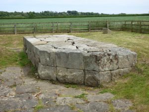
The Roman road from York to the North of England crossed the river Tees at this point. Portions of masonry that where interpreted as a Roman bridge were found in 1972 in advance of gravel quarrying.
The Roman road from York to the North of England crossed the river Tees at this point. Portions of masonry that where interpreted as a Roman bridge were found in 1972 in advance of gravel quarrying.
← World Heritage Arka Unskel hillfort, Highlands Arka Unskel is 2½ miles ESE of Arisaig at NM693839 and has also been known as Arisaig Fort, Ard Ghaunsgoik Read more Castle Hill, Almondbury Castle Hill’s imposing silhouette hides a great prehistoric fort, Norman castle and Victorian tower. Thanks to Varley’s trenches and the Read more West …

Finavon Hill has attracted a great deal of archaeological interest from antiquarians and archaeologists over the years especially since it displayed traces of vitrified rock.

This island, locally termed Eilean na Goar, is the most eastern and is bounded on all sides by precipitous gneiss rocks; it is the abode and nesting place of numerous sea birds. The flat surface on the top is 120 feet from the sea level, and the remains of the vitrified fort are situated on this, oblong in form, with a continuous rampart of vitrified wall five feet thick, attached at the SW end to a large upright rock of gneiss

The Medieval Castle, the most prominent feature in the hill, stands inside, and is built from the debris of, an oblong vitrified fort, a maximum length approximately 70 m, which crowns the summit. Outworks, most clearly marked on the E, may be associated with this phase.
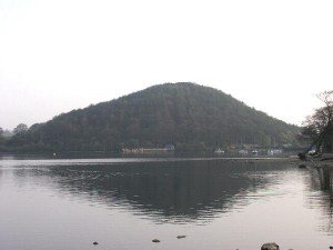
Dunmallard Hill, shrouded in trees, hides a true hill-fort. It uses the steep slopes of the hill to good effect, adding to the defence with a deep ditch and rampart within.

Craig Phadraig is a hilltop fort within a Forestry Commission plantation, 2.5km west of Inverness. It occupies a position with excelent views over the Beauly Firth.

This site was occupied in several periods, originally late Bronze age between 700 – 500BC. Firstly a simple farmstead which expanded to a blockhouse (fort) and then by a huge circular broch. A population of around 60 lived in this little fortress. Later, 2nd century occupation is shown when a wheelhouse was added.
← World Heritage Arka Unskel hillfort, Highlands Arka Unskel is 2½ miles ESE of Arisaig at NM693839 and has also been known as Arisaig Fort, Ard Ghaunsgoik Read more Castle Hill, Almondbury Castle Hill’s imposing silhouette hides a great prehistoric fort, Norman castle and Victorian tower. Thanks to Varley’s trenches and the Read more West …
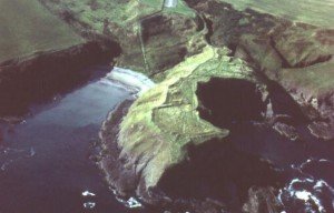
10 miles W of Fraserburgh. Access to this promontory fort is by a motorable track N from the B9031, W of the steep-sided valley of the Tore of Troup.
 NLS Map Explorer
 Google Earth
 Google Maps
 Lidar Finder
 TMA
TMA
 Megalithic Portal
 Yorkshire Arch. Air Mapping
 ADS
ADS
 Brigantian Adventure FB Group
Stone Bothering FB Group
Stone Faces FB Group
Brigantian Adventure FB Group
Stone Bothering FB Group
Stone Faces FB Group
 Heritage Gateway
 ARCHI® MAPS: UK
 Atlas of Hillforts
 Portable Antiquities
 British History Online
Brigantes Nation FB Group
British History Online
Brigantes Nation FB Group

