

“Coal Barns”, are, in the case of Coverdale, and smaller coal producer, often, simply ordinary barns, which have been used, and perhaps partially converted for use as coal storage.
May 20
“Coal Barns”, are, in the case of Coverdale, and smaller coal producer, often, simply ordinary barns, which have been used, and perhaps partially converted for use as coal storage.
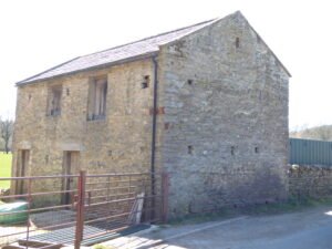
The barn that is located closest to Nathwaite Bridge seems important, but is poorly understand and recorded. It’s position, in close proximity to the bridge, together with three arrow-slot style defensive features indicate it may have served to protect the Carlton side of the river from raiders, and is in a perfect position, strategically. Yet, it is not recorded as such, and may be later in its creation, as it does not appear on some earlier maps.
May 20
Coverdale never possessed the thick, profitable seams that powered the great Yorkshire coalfield; instead it sat on the very feather-edge of the Yoredale Series where thin coal bands (18 – 50 cm) lie between the well-known limestone, sandstone and shale rhythms.

Geophysics and three hand-excavated trenches uncovered ten further uprights, in addition to the known standing stone at Farley Moor Woods, lying just below the leaf-litter, defining a ring c. 18 m in diameter around the visible stone. A low stone-built platform or “kerb cairn” occupies the circle’s south-eastern arc; charcoal lenses and a smashed Collared-Urn sherd in its make-up gave an early Bronze-Age radiocarbon estimate of c. 1700 BCE (3,700 cal BP).
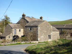
West Scrafton is a village located in Coverdale in the Yorkshire Dales. It sits on the southern upward slops of Coverdale, and had its most recent heyday in the 19th century when coal mining took over the village.

Flats Hill mound is approximately 30 meters in diameter and stands about 3.6 meters high. It has never been excavated, although a dry stone wall seems to have been started, and then stopped, partly over its top. It has been suggested as, and is listed as a probable barrow, with a presumably wide date, likely to be in the Bronze Age or Iron Age date range.

Coverdale, located within the Yorkshire Dales National Park, is a valley of great beauty and rich history. Its unique geography, fascinating geology, and enduring heritage combine to create a truly special place. Coverdale is home to at least two Iron Age hill forts, and a long history of mining and landscape transformation

The Yorkshire Dales National Park is a large expanse of hills and dales in North Yorkshire, in northern England. During the Iron-Age, they were in the heart of Northern Brigantia.
Feb 11
The Nosterfield Quarry excavation sits at the heart of one of Britain’s most enigmatic prehistoric landscapes—the Thornborough Henges Complex.

Ingleborough Hill, located in the Yorkshire Dales, is known for its prehistoric significance, particularly its hill fort. The hill fort atop Ingleborough is located at an elevation of about 723 meters (2,372 feet) above sea level, making it one of the highest known Iron Age settlements in the region.
 NLS Map Explorer
 Google Earth
 Google Maps
 Lidar Finder
 TMA
TMA
 Megalithic Portal
 Yorkshire Arch. Air Mapping
 ADS
ADS
 Brigantian Adventure FB Group
Stone Bothering FB Group
Stone Faces FB Group
Brigantian Adventure FB Group
Stone Bothering FB Group
Stone Faces FB Group
 Heritage Gateway
 ARCHI® MAPS: UK
 Atlas of Hillforts
 Portable Antiquities
 British History Online
Brigantes Nation FB Group
British History Online
Brigantes Nation FB Group

