Category: Human Remains

South Street Long Barrow, Avebury

South Street Long Barrow - Stukely plate including South Street Long Barrow

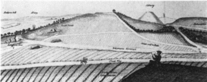
South Street long  barrow once lay 1 km south‑west of Avebury village, midway between the Kennet spring‑line and the Windmill Hill plateau (OS grid SU 090 678; 165 m OD). From its crest the ground falls gently north‑east toward the henge and west toward Beckhampton, so the mound would have been visible from all Early‑Neolithic foci in the area yet lay on good grazing that could be tilled by the first farming groups.

Millbarrow long barrow (Winterbourne Monkton)

Tumulus on Millbarrow

Millbarrow once stood on a low chalk spur 2 km north‑west of Avebury, just above the spring‑line where the Kennet valley opens onto the Marlborough Downs (NGR SU 0943 7221). From its east–west‑aligned crest the ground falls gently south to Windmill Hill and east  into the Kennet valley, giving the mound clear sight of the Avebury monument complex, and easy access to water and pasture.

Contact Us
close slider