Notice: Function WP_Scripts::add was called incorrectly. The script with the handle "datatables-responsive" was enqueued with dependencies that are not registered: datatables. Please see Debugging in WordPress for more information. (This message was added in version 6.9.1.) in /home/u621095157/domains/brigantesnation.com/public_html/wp-includes/functions.php on line 6131
This denuded hillfort is oval and encloses almost two acres. The defences comprise triple circuits of bank and ditch, with Read more
Barry Hill hill-fort
Barry Hill Fort - Cateran Ecomuseum
Barry Hill is a textbook “big fort waiting for a small trench”: its spectacular vitrified rampart, enigmatic outer works and Arthurian folklore offer equal attraction to scientists and story-lovers—yet almost everything we know comes from surface survey. A single, well-designed excavation season could pivot the site from picturesque curiosity to a securely dated anchor point in the defensive story of eastern Scotland.
Barry Hill hill-fort (NO 262 503) – what the evidence says so far
A summary of the topography, archaeology, investigation history and research potential for the partly-vitrified stronghold that crowns Barry Hill above Alyth, Perth & Kinross.
Setting and overall layout
Position – A freestanding volcanic plug (265 m OD) on the lip of Strathmore, commanding the mouth of Glen Isla and long views up to the Cairngorm front. (Historic Environment Scotland)
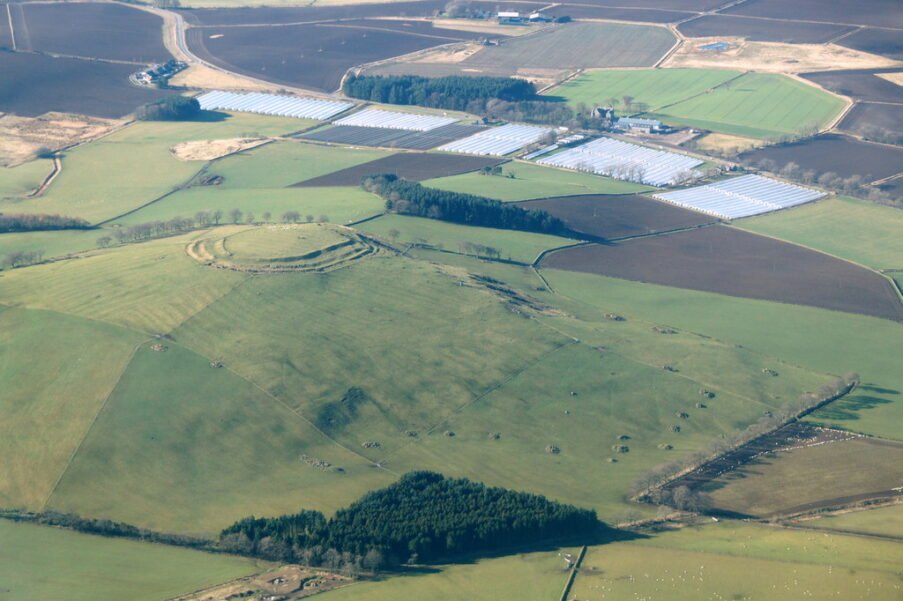
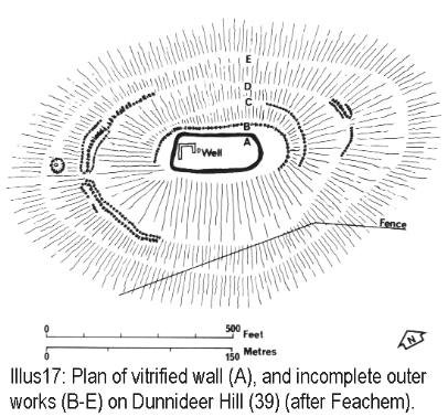
Inner works – A timber-laced stone rampart 10 m wide, fused in places to glassy slag, encloses an oval summit 78 × 23 m. On the south-east it still rises 2.5 m above the interior and 7 m above a shallow external ditch. (Canmore, Historic Environment Scotland)
Outer circuit – A second, earth-and-stone wall up to 15 m thick runs round a terrace on the S and E, then fades into steep natural slopes on the N and W; its full extent and date remain unclear. (Canmore, Canmore)
Water feature – A small pond sits just below the western shoulder; regional research has highlighted Barry Hill and Abernethy as rare Scottish forts with possible artificial hill-top water bodies. (scarf.scot)
Chronicle of investigations
Date
Activity
Outcome
18th–19th c. antiquaries
Macfarlane (1720s) & New Statistical Account note colossal wall and local Arthurian legend.
First published record; hill named ‘Barrow Hill’ on early estate maps. (The Modern Antiquarian)
Comparative morphometrics set Barry Hill alongside Dundurn and Burghead as an Early-Medieval “nuclear fort”.
Re-frames site as a possible Pictish power-centre, not just Iron-Age. (ResearchGate)
2022 – Perth & Kinross Regional Framework (PKARF)
Collates radiocarbon proxies from analogues; floats 400 BC–AD 50, AD 50–400 & post-AD 800 phases for Barry Hill.
Highlights need for direct dates; places fort in long-lived defensive network. (pkht.org.uk)
2023 – LiDAR & UAV modelling (Cateran Ecomuseum)
Drone-derived DEM published for outreach.
Confirms intact inner wall and reveals quarry scoops on E terrace. (Cateran Ecomuseum)
No modern excavation has yet sampled internal deposits, so all chronologies are inferential.
Chronology & cultural assignment
Iron-Age origins almost certain – Timber-laced, vitrified ramparts are diagnostic of mid-first-millennium BC defensive practice in eastern Scotland. (Canmore)
Early-Medieval (‘nuclear’) refortification possible – Massive outer bailey, pond feature and region-wide analogues hint at a Pictish or Gaelic élite re-occupying the hill between the 6th and 9th centuries AD. (ResearchGate)
Legendary layer – Since Hector Boece’s 1527 chronicle, the site has been linked to the captivity of Vanora (Guinevere) and later to Áedán mac Gabráin, anchoring it in popular Arthurian geography. (Glendiscovery, The Modern Antiquarian)
Architectural highlights
Vitrification – Glassy fusion is patchiest on the south face, implying deliberate firing concentrated where timber lacing was densest or where an attacker laid fuel. Blocks exhibit the green-black sheen typical of basaltic melt. (Wikipedia)
Gate system – A break in the east rampart, flanked by inward-facing wall-ends, may be the original entrance; erosion masks any jamb stones or guard chambers. (Canmore)
Interior – Wind-break shelters built from tumble obscure any prehistoric house platforms, but LiDAR hints at at least two circular scoops 6–8 m across on the north rim.
Why Barry Hill matters
Preservation – With 2-3 m of vitrified wall core still standing, it is one of the most dramatic unexcavated forts in Scotland. (Canmore)
Research gap – Absence of trenches means every core question—date, occupation density, reason for firing—remains open, making the hill an ideal test-bed for minimally invasive techniques (coring, archaeomagnetism, OSL).
Regional puzzle-piece – Its size and visibility complement smaller forts around Strathmore, helping model power hierarchies from the Iron Age through the Pictish era. (ResearchGate)
Public engagement – A 15-minute walk from Alyth gives easy access for community archaeology and myth-busting tours. (Cateran Ecomuseum)
Key outstanding questions & next steps
Question
Suggested method
When was each wall built and burned?
Core the inner rampart for charcoal, pair radiocarbon with archaeomagnetic sampling.
Is the pond artificial and contemporary?
Sediment coring & palaeoenvironmental analysis for anthropogenic infill and pollen spikes.
Extent of any Early-Medieval refurbishments?
High-resolution gradiometry on the outer terrace to map secondary timber buildings.
Role in local landscape
Integrate LiDAR with catchment modelling to assess visibility lines to other forts and the Roman Gask frontier.
Site of a pre-historic fort also where the Battle of Barra was fought in 1308 between King Robert The Bruce and Comyn of Buchan.
AHA Hogg, Hill-forts of Britain
'The most prominent feature of this site is the ruin of a huge and strong wall, originally timber-laced and now partly vitrified, forming an enclosure of regular plan with parallel sides and semicircular ends, area of about 0.2 hectares. There is apparently no entrance. Outside it are some additional enclosures, which can be best understood from the plan. These suggest that the vitrified fort has been built over the remains of an earlier structure. Essentially, this seems to have been protected mainly by natural crags on the north, and on the sides by a huge bank, mostly built up with material from a large quarry ditch set some way behind it, but also using a natural hump at the east end. The entrance was between this and the top of the crags. At the west end, the irregularity of the ground combined with the superimposition of the stone fort makes it impossible to work out the arrangements from surface investigation; there may have been another entrance about here through the south bank. The artificial pool is outside the defences, for the banks which enclose it are very slight.' - AHA Hogg, Hill-forts of Britain
Excavations
Excavations have uncovered items such as pottery, flint tools, and cereal remains, indicating the site's long-term occupation and use. These artifacts provide valuable insights into the daily lives and activities of the people who lived there. Additionally, the fort's construction phases suggest it was an important site during both the Iron Age and the Pictish period. These findings help archaeologists understand the historical significance of Barra Hill and its role in ancient societies.