
This page holds our Glossary of Terms for Vitrified Forts.
May 30
This page holds our Glossary of Terms for Vitrified Forts.

In the field of Bridge Barn, close to Nathwaite Bridge, there are two fords marked on the OS Series 1 map. This site page holds the details of our investigation into the fording point we think may be called Cow Ford.
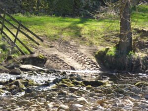
In the field of Bridge Barn, close to Nathwaite Bridge, there are two fords marked on the OS Series 1 map. This site page holds the details of our investigation into the fording point we think may be called Intach Ford.

Located in the same field as Bridge Barn, close to the Cow Ford, there is a mound. In may be around 4-5m in diameter and perhaps 1.5-2m high. Our initial search drew a blank as to what it may be. But it’s proximity to Cow Ford suggests it may have a mining, or masonic origin.
May 19
This report intends to provide an understanding of the major geological landscape of the Iberian Peninsular. We can understand Iberia as having five tectonic provinces – zones of underlying tectonic activity, caused by two plates, or distinct bodies of earth mass, are moving towards, or away from each other. This, combined with the geology of the earth at that point: the rock, etc, that forms the basic structural profile for the peninsular overall.
May 18
Antonine Wall Map Gask Ridge Map Roman Military Sites in Scotland English names, Roman names where known, four figure map reference, site type, size, and history, including garrisons and associated military Read more Mystery of Vitrified Forts It was during a trip to.Scotland, in the Summer of 1997, that I first heard of vitrified hillforts. …

Brigantia Espania is our name for our Spanish Brigantian research pages and sites. This is the beginning of our journey, and we start at the beginning.
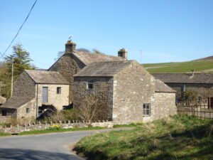
West Scrafton is a village located in Coverdale in the Yorkshire Dales. It sits on the southern upward slops of Coverdale, and had its most recent heyday in the 19th century when coal mining took over the village.

Wensleydale in the Yorkshire Dales is perhaps one of the most accessible and best known of the eastern dales. Whilst in modern times it is largely home to sheep farming and tourism. In the past it was a significant seat of power, and right in the hearlands of the Iron Age Brigantes tribe.

Nestled in the heart of the Yorkshire Dales National Park, Carlton in Coverdale is a picturesque village, surrounded by stunning landscapes. Situated in the Coverdale valley, it is a part of the Richmondshire district in North Yorkshire, England.
 NLS Map Explorer
 Google Earth
 Google Maps
 Lidar Finder
 TMA
TMA
 Megalithic Portal
 Yorkshire Arch. Air Mapping
 ADS
ADS
 Brigantian Adventure FB Group
Stone Bothering FB Group
Stone Faces FB Group
Brigantian Adventure FB Group
Stone Bothering FB Group
Stone Faces FB Group
 Heritage Gateway
 ARCHI® MAPS: UK
 Atlas of Hillforts
 Portable Antiquities
 British History Online
Brigantes Nation FB Group
British History Online
Brigantes Nation FB Group

