
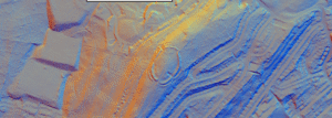
This is an oval fort with an internal area of 2.5 acres. A bank, ditch and counterscarp bank are continuous around it except on the N side where ditch and counterscarp have been destroyed.
This is an oval fort with an internal area of 2.5 acres. A bank, ditch and counterscarp bank are continuous around it except on the N side where ditch and counterscarp have been destroyed.

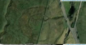
Scholes (or Scoles) Coppice Camp (sometimes called “Caesar’s Camp”) lies just north-west of Kimberworth in Rotherham, atop the same Magnesian Limestone ridge that carries the Roman Rig. Its grid reference is roughly SE 436 937, placing it only 200–300 m to the north of the Rig’s northern branch

The Roman Rig is a defensive dyke built to defend against attack from the south. It runs from Sheffield, past Templeborough and carries on almost to Doncaster. If this is a Brigantian dyke it would certainly add weight to Websters definition of the Roman border in the period.
Dryburn Henge lies on Alston Moor in Cumbria, within the North Pennines Area of Outstanding Natural Beauty. It occupies a strategic nodal point on the high moor, roughly at NY 760 430, where routes across the Pennine watershed converge. The surrounding terrain is underlain by Carboniferous Great Scar Limestone and interbedded Yoredale shales, with scattered fluvioglacial gravels in valley bottoms.

This mound is 22ft. in diam. and about 3ft high. It has been built upon a natural knoll which makes the barrow look larger than it is. Excavation showed that the mound has an earthy core with a rubble capping.

This unexcavated and undated barrow matches many of other Late Neolithic / Early Bronze-Age round barrows (c. 2400–1500 BC) dotted along the flanks of the Yorkshire Dales.

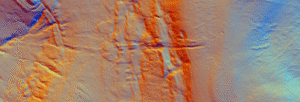
The Cleave dyke system is several Dykes which combine to create a boundary of between 9 and 18 kilometres running north south to the west of Thirsk.
Black Dike is the diminutive counterpart to the great Tor Dike, rising from its western arm and climbing to the watershed between Great and Little Whernside. Beginning at roughly SD 988 756—where Tor Dike cleaves the limestone scarp—the Black Dike pursues a steep, sinuous course uphill for nearly 0.6 km, finally spilling onto the ridge crest at about 675 m above sea level
Jun 27

A gazetteer of probable prehistoric mounds, cairns and boundary earthworks in Coverdale. It is not complete and is still being researched.
Jun 16
Over the last five years Iron-Age specialists have been re-examining what British hillforts were really for. The question is no longer just “fortress or farm?” but whether many of them were built first and foremost as places of gathering, display and ritual.
 NLS Map Explorer
 Google Earth
 Google Maps
 Lidar Finder
 TMA
TMA
 Megalithic Portal
 Yorkshire Arch. Air Mapping
 ADS
ADS
 Brigantian Adventure FB Group
Stone Bothering FB Group
Stone Faces FB Group
Brigantian Adventure FB Group
Stone Bothering FB Group
Stone Faces FB Group
 Heritage Gateway
 ARCHI® MAPS: UK
 Atlas of Hillforts
 Portable Antiquities
 British History Online
Brigantes Nation FB Group
British History Online
Brigantes Nation FB Group

